The project’s proposal
The meeting was the occasion to present the Mapping METREX project, which was initiated by the Province of South Holland and first presented at the Braga Conference in 2023. The goal is to deepen the knowledge around the territorial diversity and variety of governance systems offered by the METREX membership by connecting and visualizing existing information and making it easily available. The main idea is to learn more about the Members to create shared opportunities of understanding of the metropolitan dimension in Europe. What is the picture?
There is already a lot of data available at European scale through different platforms, but the information is often fragmented, but how to make it valuable, understandable, accessible? And furthermore, how does it relate to the Members that are part of this community?
The Pilot version
The pilot elaborated by the PZH tries to bring the existing data together in one viewer: for Mapping METREX
Indicators and data tested in the pilot
This viewer aims to make information about the Metrex members easily accessible for these members.
Among others, indicators include:
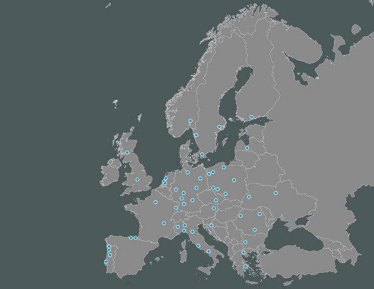
Members borders
The hardest task was mapping the territories of the Members. This was done by five people using the borders from the websites. Members are all different and so this was a difficult task. It will need to be checked, but this first step shows the diversity.
Governance system
Four categories, depending on whether the member is a city, an area that is elected or not, or a collaboration.
2021 list of European Metropolitan Areas from Eurostat
What this shows is an overview of places that are not but could be members of METREX.
Infrastructure
This is being mapped from OpenStreetMap and include rail and high-speed rail, roads.
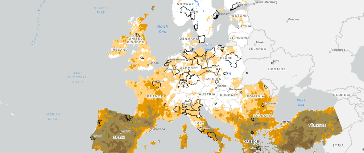
Regions that are growing and shrinking between 2015 and 2022
This layer identifies common challenges among Members and can provide insight for learning.
Land use
This layer offers a clear view on the existing relationship between urban and rural at the EU level.
Projections
This layer includes data on common challenges like climate change, demographic transition, expected drought, air quality.
Who can participate to the project?
METREX welcomes all Members to collaborate on this project.
What is the timeline of the project?
Autumn 2023: Launch of the idea.
Spring 2024: Testing the pilot version and exchange with members.
May 15-16: METREX Spring conference
The project’s opportunities and possibilities are being discussed in combination with the launch of the METREX activities programme.
May-June 2024: Creation of a core group to work on objectives, data required and methodology and definition of the funding.
Summer 2024: Development of the proposal / idea with inputs from the METREX Program of activities.
METREX Autumn Conference 2024: presentation of a prototype ready for implementation.
Discussion
Indicators and themes: Which areas do Members think are important to expand on? Expertise or qualitative data?
Comments and issues raised
- ‘Competences’ would allow collaboration, but this data is not yet available and would be very labour intensive.
- Policy development and analysis will be useful from this map. However, this is not a simple progress. Time, huge effort and cooperation to provide data. Have a clear idea of what is the main goal, which will help define a methodology and data required. Data comparison and reliability is then key – how can the platform be used to help our vision for a metropolitan Europe? The Espon Metro project could provide some guidance on the methodology.
- Città metropolitana Milano is working on open data and is working on a new plan on data collection.
- Brno doesn’t have data on the metropolitan region, so it would be labour intensive. Some of the data would need to be collected and created as a metropolitan layer.
- Technical support: Which platforms do Members use?
- Operational development and implementation: How to make it work? Are Members ready to share data? How can a platform be created for members to work on?
Some of the definitions of governance might be a tricky issue to solve. Especially where associations are concerned. The goal is to give Members access so that they can make their own changes. But who has the oversight on this, it is not clear yet.
It was suggested that covering all metropolitan areas, not just METREX Members. With a filter to highlight Members. Modules can be added above main statistical framework if any more in-depth information is required.
- Access to additional data
DG Regio has good data on railways and relevant metadata (speed, capacity). Maybe they can share it (Martin Gauk, ESPON).
Open questions to Members
Considering that the Province of South Holland cannot lead this forever therefore it is important to consider what’s next?
- What do you think about a next phase/ follow-up?
- Which are relevant topics/ layers/ legenda to add to this database?
- How do we share information and keep it up to date?
- Who wants to join us in this conceptual phase?
References
Some references shared during the meeting:
Passenger rail performance in Europe
ESPON METRO | The role and future perspectives of Cohesion Policy in the planning of Metropolitan Areas and Cities
(Brno was part of it) might inspire the development of the platform
ESPON IMAGINE – Developing a metropolitan-regional imaginary in Milan-Bologna urban region
(Metropolitan city of Milano was part of it)
For more information contact Viviana Rubbo.